
Safety-first walking navigation app. Find the safest routes with real-time Walkable Score based on lighting, foot traffic & crime data. Choose Safe, Balanced or Fastest.
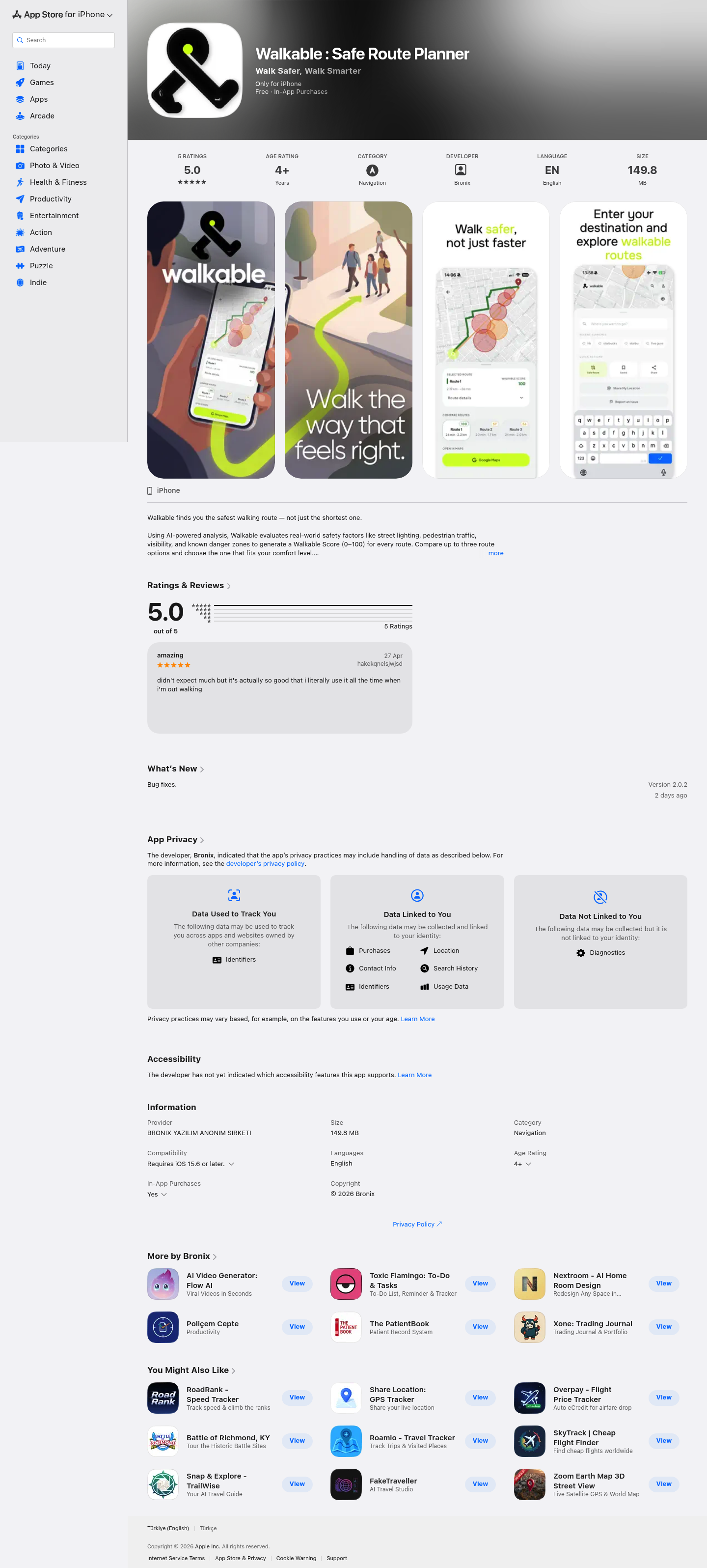
Walkable is an AI-powered navigation app that prioritizes your safety over speed. Unlike traditional mapping tools that only calculate the shortest distance, Walkable analyzes real-world safety factors like street lighting, pedestrian traffic, and visibility to help you choose the most secure walking route.
Walkable serves urban pedestrians, night commuters, solo travelers, and anyone who values personal safety when walking. The app is particularly valuable for women, students, tourists, and residents of cities with varying neighborhood safety levels who want data-driven route decisions.

AI fundraising agent that finds investors and books meetings

OpenClaw in Slack that makes your company autonomous

Track who's advertising across podcasts w/ campaign insights

Your AI Teammate now responds and executes during your calls

Fully local, natural language search over terabytes of media

A collaboration space for 10x teammates with their Al agents

Build Your Own AI Desktop

AI social media copilot for teams and agents

Your AI BDR that runs outbound sales autonomously

Notify your AI agent when the web changes

Chat with your business data inside Claude, ChatGPT and more

Context-aware Mac keypad, w/ Claude + community extensions

Give your Sales and CS teams engineering superpowers

On-brand presentations, generated in seconds

The world’s smallest smart ring, now even better

AI autocomplete for every app on your Mac

the AI in your texts that gets stuff done

Persistent memory for Claude, ChatGPT & Cursor. Free.

Your AI creative team for video ads

AI for Software Engineering

Trade 500+ markets directly from ChatGPT & Claude
The AI Marketing Agent Powered by Ahrefs Data

AI agents for real-time aircraft monitoring and alerts

Navigate your agents to product-market fit

Zero servers. Total privacy. Your new favorite toolbox.

AI roleplays that turn reps into top performers

Track your browser extensions and competitors in one place

One API to publish across every social platform.
Take your presentation skills to the next level

Infinite clipboard for Claude, Codex and other AI tools

Monitor your mcp server

Connect any API to any AI agent

Flash-speed agents model that can see and act

Your AI-powered bookmark manager

Generate fast, reliable APIs for any platform. No browsers

A database of 125K+ angels and VCs to raise your seed round
Let your agent trade

A new way to review PRs, directly inside Linear

Persistent memory from agent trace, not just conversation

Run a research agent with cited answers in a single API call

Advertise together on Meta Ads and pay 3x less
Lock your keyboard and prevent cats from causing chaos

Keep your Mac awake

Your ultimate NotebookLM's Chrome Extension

Preview and Publish your Markdown

Chrome extension that replaces "AI" with 💩

Travel back to 1998 and use Lovable on Windows 98

The autopilot for YouTube post-production

I agent for long-running, multi-step work and coding

Describe your shot. Rodeo builds your first cut.

A smart LLM proxy that shows where you're overpaying

A vault for every document that matters

Merch for distributed teams, handled end to end

Use iPhone to open apps, Apple Shortcuts and websites on Mac

A fun new way to create & manage brands.

Screen recording for demos, bugs, and updates

A focus companion that actually gets context

Secure way to share apps built with AI Agents

The go-to ruler for designers and developers

Your Mac's camera is now a heart-rate sensor

Never miss a celestial event, anywhere on Earth

Turn your AI agents from interns to veterans

Give customers AI analytics inside your product.

Local natural language search across all your files

Real-time text-to-speech model you can self-host

Generate more accurate investment dashboards and reports

Build, manage, and ship customer messaging from Slack

Turn coding agents into specialist teams

Control your robots from anywhere in the world

Browser piano studio with visual harmony tools
Plan and track your trips privately

User onboarding now with an AI copilot

The intelligence layer for Apple Health

The AI dev environment built for your phone.

Mac dynamic island with music, timers, clipboard, file drops

Living docs + MCP context for your GitHub repos

Real API data in your mockups made as easy as lorem ipsum.

Unlock hidden App Store Connect analytics

Talk to your computer, it responds and gets things done.

Voice AI copilot for coworking & coliving operators

Bring Back the Classic Launchpad Experience on macOS 26+

LLM usage tracking that lives in your Mac's notch

Search all your screenshots via a local OCR-powered AI

Local AI workspace to build and work with your computer

Turn your Google Drive into a stunning client gallery

Smart travel planning made effortless

Trace AI requests, workflows, and costs in one timeline

Real-time AI captions and translation for any browser video

AI Video Cutter for viral Shorts, Reels, TikTok in Telegram

HTTP(s) proxy debugger with custom viewer

Simulate real store with LLM-powered synthetic consumer

Design a home instantly with AI

Make your business citable by ChatGPT, Claude & Perplexity

Brighten your video calls with different toned ring lights

Self-learning one-click inbox cleanup for Apple Mail

Your coding agent finally remembers your repo
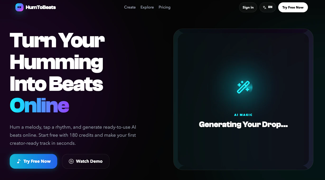
Turn humming into AI-generated beats

Bridge your live frontend directly to your AI agent.

Track rising Hacker News posts before they explode

Control AI coding agents with limits, proof, + run receipts